


Risetenpass
 |
CH (GL-SG), 9.2464°E, 46.9781°N | |||
 |
2189 m |  |
CH-GL-2189 | |
 |
Matt, 831m, 11km Vordere Winggelhütten, 1432m, 4km Ober Stafel, 1886m, 1km | |||
 |
Weisstannen, 1004m, 8km Stosschopf, 1640m, 4km Obersiezsäss, 1662m, 3km | |||
 |
||||
 |


")
| |||
 |
nice passage between the cantons of Glarus and St. Gallen, but carrying or pushing required on the last kilometre of the Glarus slope (steep trail) | |||
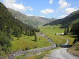
Winggelhütten in the Chrauchtal | ||||
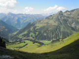
View towards Matt from Risetenpass | ||||
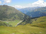
Obersiezsäss and the valley of Weisstannen as seen from Risetenpass | ||||