


Pass Maighels / Maighelspass
 |
CH (UR-GR), 8.6801°E, 46.5948°N | |||
 |
2421 m |  |
CH-GR-2421 | |
 |
Andermatt, 1436m, 11km Vermigel, 1965m, 3km | |||
 |
Tschamut, 1640m, 12km Lai Urlaun, 2260m, 4km Planca avon Purtgera, 2347m, 1km | |||
 |
||||
 |


")
| |||
 |
hiking pass, rideable in the Unteralp valley up to Vermigel, in the Val Maighels up to Stavel da Maighels, pushing or carrying (but not too difficult) in between | |||

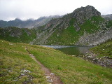
Vermigel, the path to the Maighelspass climbs on the left | ||||
Pass Maighels | ||||

Val Maighels | ||||