
 MTB tour Escholzmatt - Schangnau - Grünenbergpass - Habkern - Kemmeriboden - Escholzmatt (19 October 2013)
 |
67 km |
| 1703 m ^ | |
 |
Schangnau as seen from the other side of the Emme river 19-10-2013 11:29 7.8592°E, 46.8164°N, 940m |
 |
Schangnau as seen from the other side of the Emme river 19-10-2013 11:35 7.8544°E, 46.8131°N, 1030m |
 |
Marbachegg and Schrattenfluh as seen from Scheidzunbödeli 19-10-2013 11:48 7.8469°E, 46.8028°N, 1160m |
 |
Rotmoos 19-10-2013 11:54 7.8425°E, 46.7936°N, 1192m |
 |
Farm at Rotmoos 19-10-2013 11:55 7.8425°E, 46.7936°N, 1192m |
 |
Rotmösli and in the background Sichlepass with Burst and Gemmenalphorn 19-10-2013 11:57 7.8433°E, 46.7897°N, 1190m |
 |
Trüschhübel, view towards the valley of Eriz 19-10-2013 12:04 7.8444°E, 46.7750°N, 1170m |
 |
Near Fall 19-10-2013 12:12 7.8450°E, 46.7694°N, 1250m |
 |
Alp of Fall 19-10-2013 12:12 7.8450°E, 46.7694°N, 1250m |
 |
The valley of Eriz as seen from Grünenberg 19-10-2013 12:45 7.8522°E, 46.7644°N, 1550m |
 |
Trogenmoos and the Bernese Alps 19-10-2013 12:57 7.8583°E, 46.7594°N, 1480m |
 |
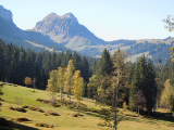
Eiger, Mönch and Jungfrau as seen from Trogenmoos 19-10-2013 12:58 7.8583°E, 46.7592°N, 1480m |
 |
Trogenmoos and Hohgant 19-10-2013 13:01 7.8583°E, 46.7583°N, 1460m |
 |
The hamlet of Bolsiten as seen from Habkern 19-10-2013 13:12 7.8622°E, 46.7314°N, 1120m |
 |
View from Schwendi towards Habkern 19-10-2013 13:24 7.8717°E, 46.7281°N, 1130m |
 |
The mountain chain of Augstmatthorn as seen from Schwendi 19-10-2013 13:35 7.8839°E, 46.7303°N, 1260m |
 |
Rotenschwand 19-10-2013 14:08 7.9047°E, 46.7417°N, 1530m |
 |
Feldmoos 19-10-2013 14:14 7.9083°E, 46.7458°N, 1560m |
 |
Feldmoos, Hohgant and on the right Schrattenflue 19-10-2013 14:15 7.9086°E, 46.7467°N, 1563m |
 |
Hohgant as seen from Saagiegg 19-10-2013 14:21 7.9006°E, 46.7517°N, 1595m |
 |
Lombachalp with Tannhorn on the right 19-10-2013 14:23 7.8975°E, 46.7544°N, 1590m |
 |
Sattelmoos, with Tannhorn on the right 19-10-2013 14:34 7.9131°E, 46.7650°N, 1570m |
 |
Äbenegg 19-10-2013 14:39 7.9136°E, 46.7692°N, 1520m |
 |
The valley of Bumbach and Schrattenflue 19-10-2013 15:08 7.9075°E, 46.8136°N, 940m |
 |
Farm in the valley of Bumbach 19-10-2013 15:09 7.9075°E, 46.8136°N, 940m |