


Kastensattel
 |
CH (AI-SG), 9.4864°E, 47.2861°N | |||
 |
1678 m |  |
CH-AI-1678 | |
 |
Rüthi, 431m, 13km | |||
 |
Brülisau, 922m, 5km Ruhsitz, 1279m, 2km | |||
 |
||||
 |


")
| |||
 |
long paved road up to Kamor; trail with steps between the pass and Ruhsitz, then paved again from there to Brülisau | |||
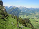
View from the north ridge of the Kamor towards the Alpstein | ||||
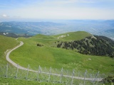
Alp Stofel (Oberkamor), Rhine valley and lake of Constance as seen from the Kamor | ||||
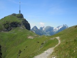
Hoher Kasten and Kastenpass, through which the Alpstein massif is visible (Saxerfirst and Altmann) | ||||