


Bistinepass
 |
CH (VS), 7.9802°E, 46.24°N | |||
 |
2417 m |  |
CH-VS-2417 | |
 |
Glis, 680m, 19km Mättwe, 1830m, 4km | |||
 |
Niederalp, 1820m, 5km Bielti, 1888m, 3km | |||
 |
||||
 |


")
| |||
 |
beautiful track, difficult or non-rideable parts, long on the side of the Nanz valley but possible to combine with Nanzlicke or Magelicke | |||
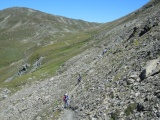
In the Nanztal, the Bistinepass | ||||

Bistinepass, view to the west | ||||
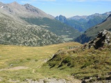
The south side of the Simplon pass as seen from the Bistine alpine meadows | ||||