


Col d'Izoard
 |
FR (05), 6.735°E, 44.8194°N | |||
 |
2361 m |  |
FR-05-2360 | |
 |
Guillestre, 1000m, 32km L'Estéyère, 1345m, 15km | |||
 |
Briançon, 1227m, 21km | |||
 |


")
")

")
| Tour 2001 | ||
 |
high pass on the Hautes-Alpes road, good road but somewhat irregular slopes | |||
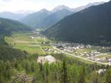
Brunissard and La Chalp as seen from the Izoard road | ||||
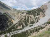
The Izoard pass as seen from the Plâtrière pass | ||||
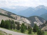
Near the Izoard pass, south slope, with the Pics de la Font Sancte in the background | ||||
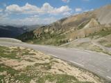
At the Izoard pass, the road on the north side | ||||