
 Tour 2012, stage 4: Barcelonnette - Allos - Cayolle - Barcelonnette (25 June 2012)
 |
122 km |
| 3290 m ^ | |
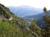 |
The Ubaye valley as seen from the road to the Allos pass 25-06-2012 08:19 6.6164°E, 44.3439°N, 1430m |
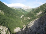 |
The Agneliers valley in the climb to the Allos pass 25-06-2012 08:29 6.6094°E, 44.3331°N, 1540m |
 |
Allos pass, its slope to Allos 25-06-2012 09:39 6.5906°E, 44.2983°N, 2240m |
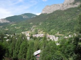 |
Colmars 25-06-2012 10:37 6.6317°E, 44.1814°N, 1300m |
 |
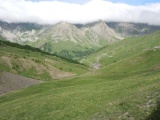
Col des Champs, slope of Colmars 25-06-2012 11:43 6.6858°E, 44.1772°N, 2040m |
 |
Col des Champs 25-06-2012 11:52 6.6978°E, 44.1753°N, 2088m |
 |
Col des Champs, slope of St-Martin-d'Entraunes 25-06-2012 11:55 6.7003°E, 44.1706°N, 2090m |
 |
La Colletta and St-Jean chapel 03-03-2024 11:44 6.7478°E, 44.1422°N, 1450m |
 |
The valley of the Var upstream of Entraunes 25-06-2012 13:32 6.7447°E, 44.2092°N, 1540m |
 |
Estenc, south of the Cayolle pass 25-06-2012 14:26 6.7586°E, 44.2469°N, 1930m |
 |
Cayolle pass, north side 25-06-2012 15:11 6.7458°E, 44.2850°N, 2000m |
 |
In the valley of the Bachelard, view upstream 25-06-2012 15:27 6.7067°E, 44.3214°N, 1730m |