
 Tour 2021, stage 2: Thun - Gestelen - Pillon - La Forclaz - Les Diablerets (20 August 2021)
 |
103 km |
| 2810 m ^ | |
 |
Gwatt and Thun from Gwattegg 20-08-2021 08:05 7.6211°E, 46.7169°N, 634m |
 |
From Gwattegg to the south 20-08-2021 08:07 7.6211°E, 46.7169°N, 634m |
 |
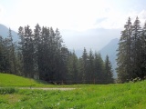
Zwischenflüh, Diemtigtal 20-08-2021 09:18 7.5139°E, 46.6089°N, 1090m |
 |
Meniggrund 20-08-2021 09:36 7.4867°E, 46.6103°N, 1270m |
 |
Gasebode 20-08-2021 09:43 7.4669°E, 46.6056°N, 1320m |
 |
Undergestele 20-08-2021 10:15 7.4419°E, 46.5928°N, 1600m |
 |
Undergestele 20-08-2021 10:17 7.4403°E, 46.5931°N, 1610m |
 |
From the Luegle to the south, with the Spillgerte mountain at the horizon 20-08-2021 10:51 7.4233°E, 46.5869°N, 1931m |
 |
Luegle pass to the north, Bunschlere Alp 20-08-2021 10:51 7.4233°E, 46.5869°N, 1931m |
 |
Gestelenpass, with the Gummfluh Massif at the horizon 20-08-2021 10:58 7.4256°E, 46.5839°N, 1860m |
 |
Gestelenpass, Diemtigtal side 20-08-2021 11:01 7.4236°E, 46.5825°N, 1852m |
 |
Gestelenpass, Zweisimmen side 20-08-2021 11:02 7.4233°E, 46.5825°N, 1852m |
 |
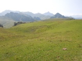
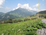
Meieberg, with the Wildhorn and, closer, the Giferspitz mountains 20-08-2021 11:04 7.4186°E, 46.5828°N, 1820m |
 |
Meieberg 20-08-2021 11:07 7.4156°E, 46.5817°N, 1770m |
 |
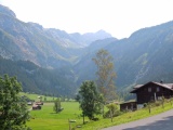
The Simmental valley as seen from Homad, with the Jaun pass in the middle 20-08-2021 11:16 7.4056°E, 46.5797°N, 1660m |
 |
The valley of the little Simme river as seen from Oeschseite 20-08-2021 12:16 7.3506°E, 46.5308°N, 1150m |
 |
Saanen 20-08-2021 12:44 7.2833°E, 46.4875°N, 1120m |
 |
Church of Gsteig 20-08-2021 13:25 7.2672°E, 46.3842°N, 1190m |
 |
From Gsteig towards the Sanetsch pass 20-08-2021 13:26 7.2672°E, 46.3842°N, 1190m |
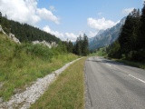 |
Pillon pass, east side 20-08-2021 14:01 7.2081°E, 46.3542°N, 1540m |
 |
Vers-l'Église 20-08-2021 14:57 7.1314°E, 46.3536°N, 1120m |
 |
La Forclaz 20-08-2021 15:21 7.0744°E, 46.3511°N, 1270m |
 |
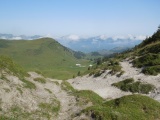
Sight over Chablais from Les Cougnons 20-08-2021 15:40 7.0600°E, 46.3417°N, 1400m |
 |
Near La Golette, wiew towards Pic Chaussy 20-08-2021 15:45 7.0683°E, 46.3453°N, 1390m |