
 Tour 2025, stage 2: Marly - Treyvaux - Marly (8 August 2025)
| 630 m ^ | |
 |
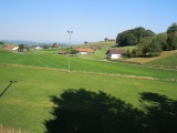
Le Mouret 08-08-2025 08:51 7.1694°E, 46.7403°N, 780m |
 |
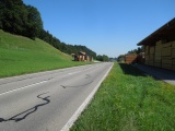
En Crosa, between Montévraz and Treyvaux 08-08-2025 09:08 7.1528°E, 46.7328°N, 864m |
 |
La Challa near Treyvaux 08-08-2025 09:18 7.1522°E, 46.7283°N, 866m |
 |
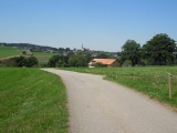
La Golette near Treyvaux 08-08-2025 09:24 7.1544°E, 46.7247°N, 830m |
 |
Between Treyvaux and Pont-la-Ville, with Gruyère lake and Moléson mountain 08-08-2025 09:49 7.1192°E, 46.7100°N, 830m |
 |
Le Pertet, chapel of Vègre d'Avau 08-08-2025 09:58 7.1264°E, 46.7083°N, 890m |
 |
Plain of La Pra 08-08-2025 10:30 7.1319°E, 46.7039°N, 830m |
 |
La Pra as seen from Le Crau 08-08-2025 10:36 7.1239°E, 46.7014°N, 815m |
 |
Le Crau and the Müllera farm 08-08-2025 10:36 7.1239°E, 46.7014°N, 815m |
 |
Crosa en dessus de La Roche 08-08-2025 10:49 7.1383°E, 46.7044°N, 830m |
 |
From Crosa towards La Pra and the Gibloux mountain 08-08-2025 10:51 7.1400°E, 46.7053°N, 836m |
 |
Pratzey pass towards La Gruyère 08-08-2025 11:08 7.1567°E, 46.7153°N, 805m |
 |
Pratzey pass towards Fribourg 08-08-2025 11:08 7.1567°E, 46.7153°N, 805m |
 |
Pra du Plan as seen from Montévraz-Dessus 08-08-2025 11:38 7.1747°E, 46.7228°N, 910m |
 |
Montévraz-Dessus 08-08-2025 11:50 7.1756°E, 46.7233°N, 910m |
 |
Le Pertet south of Le Mouret 08-08-2025 12:00 7.1769°E, 46.7317°N, 820m |
 |
Zénauva 08-08-2025 12:03 7.1775°E, 46.7347°N, 820m |
 |
Épendes as seen from Les Creux 08-08-2025 12:22 7.1606°E, 46.7586°N, 735m |
 |
Les Creux 08-08-2025 12:23 7.1606°E, 46.7586°N, 735m |