
 Tour 2025, stage 3: Flamatt - Laupen - Schwarzenburg - Flamatt (9 August 2025)
| 780 m ^ | |
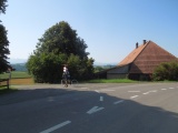 |
Sandgrube 09-08-2025 10:27 7.2711°E, 46.9022°N, 594m |
 |
The Singine river and Laupen's castle 09-08-2025 10:41 7.2397°E, 46.9014°N, 490m |
 |
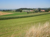
Between Noflen and Fendringen 09-08-2025 10:53 7.2500°E, 46.8906°N, 550m |
 |
Eggeli north of Niedermuhren 09-08-2025 11:45 7.2733°E, 46.8469°N, 660m |
 |
Hangbüel 09-08-2025 12:11 7.3050°E, 46.8356°N, 763m |
 |
From Hangbüel to the west 09-08-2025 12:12 7.3042°E, 46.8353°N, 760m |
 |
Old Sodbach bridge over the Singine river 09-08-2025 12:30 7.3194°E, 46.8253°N, 650m |
 |
Pöschen 09-08-2025 13:04 7.3275°E, 46.8147°N, 792m |
 |
Bergli near Schwarzenburg 09-08-2025 13:13 7.3353°E, 46.8194°N, 806m |
 |
Wahlern church 09-08-2025 13:45 7.3525°E, 46.8267°N, 840m |
 |
Loch (Hohliebe) 09-08-2025 13:58 7.3514°E, 46.8311°N, 815m |
 |
View from Loch to Wahlern 09-08-2025 13:58 7.3514°E, 46.8311°N, 815m |
 |
From Trüllplatz towards the Alps 09-08-2025 14:04 7.3569°E, 46.8328°N, 801m |
 |
Trüllplatz 09-08-2025 14:04 7.3569°E, 46.8328°N, 801m |
 |
Vue towards Schnittbifang from the south-west 09-08-2025 14:08 7.3614°E, 46.8339°N, 800m |
 |
Hubel 09-08-2025 14:16 7.3708°E, 46.8439°N, 789m |
 |
Hubel 09-08-2025 14:19 7.3697°E, 46.8431°N, 800m |