
 Tour 2012, stage 5: Barcelonnette - Parpaillon - Pontis - Barcelonnette (26 June 2012)
 |
115 km |
| 2540 m ^ | |
 |
La Condamine and the fort of Tournoux 26-06-2012 09:27 6.7411°E, 44.4567°N, 1410m |
 |
The sheepfold of Grand Parpaillon 26-06-2012 10:39 6.6686°E, 44.4836°N, 2040m |
 |
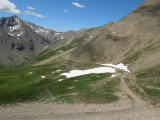
Plan de Parpaillon 26-06-2012 11:02 6.6536°E, 44.4767°N, 2230m |
 |
The Parpaillon gravel road and, in the background, Col de la Pare 26-06-2012 11:46 6.6494°E, 44.4864°N, 2620m |
 |
Patrick at the Parpaillon tunnel 26-06-2012 11:54 6.6472°E, 44.4867°N, 2637m |
 |
View to the north from the Parpaillon tunnel, with the Girabeau pass in the center 26-06-2012 12:27 6.6439°E, 44.4911°N, 2640m |
 |
Valley of the Vachères and lake of Serre-Ponçon as seen from the Girabeau pass 26-06-2012 12:44 6.6322°E, 44.5014°N, 2488m |
 |
In the descent from Parpaillon towards Crévoux 26-06-2012 13:03 6.6489°E, 44.5164°N, 2210m |
 |
Lake of Serre-Ponçon, with Embrun in the background 26-06-2012 15:17 6.3575°E, 44.5122°N, 940m |
 |
Pontis 26-06-2012 15:43 6.3533°E, 44.4978°N, 1230m |